
Malavan : Bur Gao (Burgabo; Port Dunford-Port Durnford)
-----------------------
No author mentions Bur Gao but Malavan; Malawan (Ibn Madjid: As-Sufaliyya -1470) is mentioned by Tibbetts as probably Burgao (4 or 5 zam south from Juba). As some of the ruins at Bur Gao date from the 15th-16th century this would have been possible. Claude Jouannes however says about Malawan: Without doubt the port of Kismayo itself.
Taken from: An Archaeological Reconnaissance of the Southern Somali Coast by Chittick, Neville (Azania 4 1969)
Thomas H. Wilson SITES AND SETTLEMENT PATTERNS OF COASTAL JUBALAND, SOUTHERN SOMALIA
Bur Gao may be the best port in Jubaland and beyond, but the approach to the harbour can be rough. Chittick distinguished three sites at Bur Gao Site I, a walled location about one kilometer northwest of the village; Site II, a second area of ruins on the bank of the creek about one-half kilometer north of Site I; and Site III a defensive position on Mabruk Hill about two and one-half kilometer south of the village. Site II might have been the location of earliest settlement at Bur Gao.
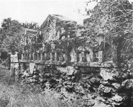
One of the most distinctive monuments of southern Somalia, at least until the collapse of its mighty pillar sometime between 1952 and 1968, was the great pillar tomb of Bur Gao (Grottanelli 1955). The pillar of this tomb rose 11 m, with a fluted section about 1.3 m high about two-thirds the way up. The 1.8 m high enclosing wall was panelled all around and deco- rated by a frieze of niches of unique design, with every fourth niche approximately doubled in height by a triangular or arch-shaped extension. The enclosure itself may be one of the largest on the coast. Chittick illustrated a second distinctive tomb from Site II, a domed tomb notable for a frieze of double niches around the upper wall. This may be the only example where decoration of a type otherwise reserved for the facades of enclosure tombs was incorporated into the design of a domed tomb. Chittick and Elliot both saw a large structure near the pillar tomb, which each suggested might be a mosque, but which neither was able to confirm. Other tombs and ruined structures lie about the site. Chittick’s ceramic collection included two sherds of celadons and five of Islamic monochrome of I5th and I6th century. But the tombs he adds (see pictures under) were of 16th-17th century.

Bur Gao is also the second place from the north which also appears in oral legends as Shungwaya and is still so named, and is remembered as the home of the (non-pastoralist) waShungwaya clan of the Bajuni. (Now the Chandaa tribe of the Bajun live there.) It is on the Bur Gao inlet in south Somalia, once the mouth of another branch of the Ewaso Nyiro. It is (nowadays at least) a suitably shallow place for getting stock across the inlet in spite of its proximity to the sea. It was from Shungwaya that the north-eastern group of Bantu-speaking tribes appears to have spread; this was certainly the case with the Nyika, or coastal tribes of that group. Chittick ends by saying it can not be Shungwaya as it is not old enough but James De Vere Allen writing in 1993 says that site 1 must be the Shungwaya site; and Shungwaya sites in other places predecessors and successors. About this site 1 Chittick gives the following description: The masonry of the defensive wall (ngome) is built of coral rubble in lime mortar and was originally plastered. It stands, where it is fully preserved, to a height of about 2.5 m. Most of it has collapsed and it is not possible to discern where the entrances were. The area enclosed extends to about seven hectares. Two subsidiary walls extend inwards from the outer enclosure; the purpose of these is obscure. At its northern comer is a pillar tomb, formerly decorated with plates inserted in the masonry, and having ornamental niches of good quality stonework. This tomb evidently antedates the building of the wall, since the latter makes a more or less semi-circular ‘detour’ round the tomb. The only standing building within the enclosure is a rectangular structure. No remains of other buildings could be discerned and even scattered building stone is lacking. One must assume that all the houses were built of temporary materials. Very few sherds were to be seen; most of those collected were of the nineteenth century and none earlier than the sixteenth. The whole area is flat, and it seems very unlikely that there is much depth of deposit.
Chittick adds that Shungwaya must have been a bit further south at Veku where was a site called Shungwaya Ndogo (small). Elliot also recorded a small walled town south of Bur Gao at the foot of a high hill called Veku, a site known as Shungwaya Ndogo. Brenner noted the ruins of buildings and a still well-preserved minaret, presumably the pillar of a tomb. The hills to the south of Bur Gao are at Shaka la Sia (on google maps: Sheeka Lasaay) 15 km to the south following the coastline from Bur Gao.