Madagascar
In this part the link will be made between the different places mentioned in the texts of different medieval authors and the reality with the help mostly of archaeology. Where Madagascar is concerned most place names come out of the Hawiya text of Ibn Majid (1470).
Two authors (1) have tried to put these places according to the given latitudes on the map of Madagascar. My map is based on those two maps but I do solve the problem of the Madagascar of Ibn Majid being to long in a different way and adopt the placements of the names according to the results of where archaeology suspects a medieval harbor. Where early Portuguese texts gave a different position for the same place I also follow the Portuguese text and not the latitude given by Ibn Majid. Further archaeological research might force me to make some changes.
(1)La Hawiya abrege versifie des Principes de Nautique; Ibrahim Khoury
Madagascar, Comores et Mascareignes à travers la Hâwiya d’Ibn Mâgid; F. Vire -J.C. Hebert.

The Southern Harbours of Madagascar
In Chapter 5 of the Hawiya Ibn Majid says: I learned that the extreme south of Qumr is at Big Bear at one finger high ………..
In two manuscripts four fingers are given; which would be more correct, but he repeats the one finger a bid later and in a later work the Umda (Sulaiman al Mahri d1550) Madagascar ends at three fingers for the Big Bear in a harbor called Hufa or Hawfa.
To adopt the map of Madagascar as Ibn Majid gives it (way too long); I leave out the piece that is clearly a copy of the part
a bid to the north. Instead of making the length of the finger shorter so that all places fit inside Madagascar. Of the four places that I delete three are clearly a copy of places found just
north of it.
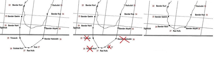
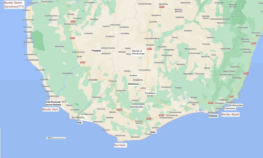
This is how southern Madagascar looks like after making it shorter. The harbors mentioned by Ibn Majid are in RED the place-names where archaeological research found traces of imports, mostly broken pots from China or the Persian Gulf are in BLACK written in a white ribbon. As can be noticed many of these places are deep in the interior of the island. The hinterland of those harbors was well developed. In my explanation on each harbor I try to divide them by harbor according to the river-valleys in which they are. It is not that transport over the rivers brought the porcelain deep inland but that the valleys were used to transport the wares.
In the central part of Madagascar, around the capital, where lots of archaeological research has taken place, numerous sites yielding imported porcelain sherds were found, but no author seems to be able to pinpoint a harbor or part of the country from which it could have been imported. Another strong indication that the hinterland of the harbors was strongly developed.
Around the capital more research has been done than anywhere else so medieval sites with imported ceramics have been found. However, it is not clear how they reached Imerina from the coast. Philippe Beaujard: Fragments of vessels carved in a stone similar to chlorite schist have been found. According to Dewar and Wright, this point to an origin of the settlers on the eastern coast. “Some sherds of heavy vessels with lugs and red-slipped bowls with grass impressions on the inside similar to those of Maliovola [in Anosy (south of the country)]” [have been recovered], revealing contacts between various regions (possibly via the eastern coast) or expressing a common culture (Dewar and Wright 1993: 440). It is likely that trade routes also existed between Imerina and the northwestern coast from or toward the Bays of Mahajamba and Boina.
Taken from: Madagascar: The Development of Trading Ports and the Interior; Philippe Beaujard.
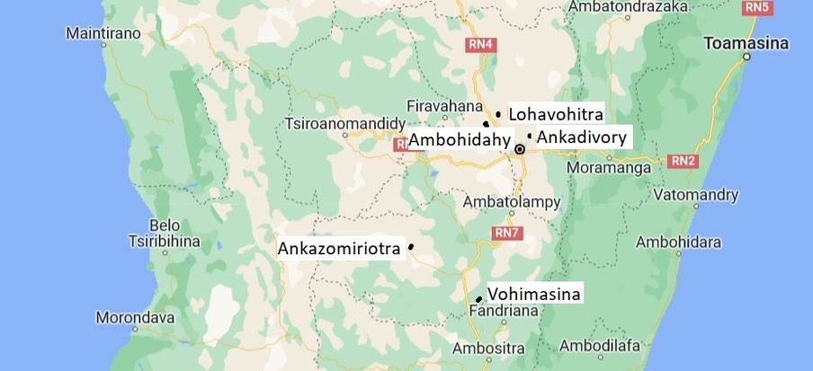
Ankadivory
Relations were probably established very early on between the coasts and the Highlands, since ceramics imported from abroad have been unearthed in Imerina. The village of Ankadivory (twelfth–fifteenth century), north of Antananarivo, is the largest site from this period (Rakotovololona 1994: 20; on dating, see Wright et al. 1992). It has yielded sgraffiato ware and eastern Asian ceramics (celadons, and white porcelain with blue decoration, which corresponds to the fourteenth–fifteenth-century dating obtained at this site). The shape of some local pottery imitates Chinese celadons.
Some jars show triangular imprints under their necks. Fragments of vessels carved in a stone similar to chlorite schist have been found. According to Dewar and Wright, these elements point to an origin of the settlers on the eastern coast. “Some sherds of heavy vessels with lugs and red-slipped bowls with grass impressions on the inside similar to those of Maliovola [in Anosy]” [have been recovered], revealing contacts between various regions (possibly via the eastern coast) or expressing a common culture (Dewar and Wright 1993: 440). It is likely that trade routes also existed between Imerina and the northwestern coast from or toward the Bays of Mahajamba and Boina.
South of Antananarivo, Ambohimanana was another major site. In the western part of the site, tripod cooking pots with handles were found, revealing connections with northeastern Madagascar and its chlorite-schist vessels (Rasamuel 2000, 2001). Ambohimanana did not yield any imported ceramic.
Taken from: The Culture History of Madagascar by Robert E. Dewar and Henry T. Wright.
These ceramics (from Imerina) are now well defined as a result of the excavations of Rakotovololona (1989, 1993) at Ankadivory and well dated to thirteenth and fourteenth centuries A.D. by C-14, thermoluminescence, and imported items (Wright et al., 1992, pp. 127-129). These ceramics differ from those of older and contemporary assemblages on the northwest, northeast, and southeast coasts.
The excavations at Ankadivory have produced ceramics imported from overseas, some Near Eastern sgraffiato, but mostly Far Eastern stone ware jar and green-glazed bowl fragments. The use of post construction and apparently of aboveground storage structures and the presence of ceramics of southeastern affinity suggest that these early cultivators of the central highlands came from the eastern forests. However, there are no local assemblages similar on the East Coast or anywhere else.
Taken from: Situating Madagascar: Indian Ocean dynamics and archaeological histories; Chantal Radimilahy; Zoë Crossland.
The highland interior:
The earliest well-dated site is Ankadivory, occupied during the twelfth to fourteenth centuries AD and located in central Imerina (Wright et al. 1992; Rakotovololona 1994). As with the earlier coastal sites Ankadivory was linked to the Indian Ocean trade, with evidence of Gulf sgraffiato sherds, plus East Asian Song Dynasty white porcelain and stoneware fragments, all dating to the twelfth/thirteenth centuries AD; chlorite-schist vessels from the east coast were also used.
Ambohidahy
Taken from: The Culture History of Madagascar by Robert E. Dewar and Henry T. Wright.
In the central Imerina, contemporary major centers of these phases are 8 to 10 km apart, typically on hills with raised springs nearby. The center of Ambohidahy 18 km north of Antananarivo is typical. The site covers 4 ha and has multiple ditches surrounding terraces with houses of unknown form, storage pits, multitiered tombs, and deep middens indicating prolonged occupation. Most of its associated tombs are outside the ditches. This settlement cluster would have had a population of about 1000 people. That Ambohidahy itself was a center of socially prominent figures is indicated not only by its size and the centrality of its tombs, but because here alone sherds of imported Far Eastern green-glazed bowls were found. (=Chinese celadon dated to between the fourteenth and sixteenth centuries)
Vohimasina
Taken from: Madagascar (Fifteenth–Sixteenth Century): The Rise of Trading Ports and Development
of the Highlands; Philippe Beaujard.
In the Vakinankaratra, the fortified site of Vohimasina overlooking the Manandona valley is dated to between the late thirteenth and sixteenth centuries. The site, covering 1.2 hectares, shows ditches on its west side, and “terraces with houses and tombs in stone disposed in a row” (Wetterstrom and Wright 1992: 155). Excavations have yielded local ceramics in the form of bowls and jars, decorated with “incised lines and imprints of small triangles, sometimes bearing traces of graphite” (Wright et al. 1992: 129).
The only imported item discovered is a single “Indian red” glass bead.
Lohavohitra
Taken from: Madagascar (Fifteenth–Sixteenth Century): The Rise of Trading Ports and Development
of the Highlands; Philippe Beaujard.
Near Lohavohitra, the site at Babay has yielded blue-and-white Chinese porcelain that may be dated to the fifteenth century (Radimilahy, p.c.). The high citadel (above 1600m) of Lohavohitra covered 0.25ha and had twelve measured structures. The hill was occupied from the fifteenth till the nineteenth century.
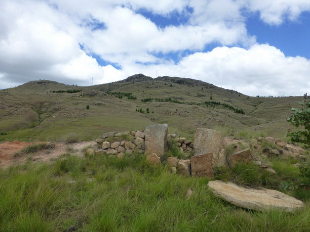
The Lohavohitra massif on the east side and at the foot a first fortified site and its 'vavahady' gate, the round disc on the ground.
Ankazomiriotra
Taken from: Madagascar: The Development of Trading Ports and the Interior; Philippe Beaujard.
A shard of sgraffiato XII- XIIIth century was retrieved further south of Ambohimanana at Ankazomiriotra (near Ambohimanambola, in the Betafo region) (Vakinankaratra). The same area has yielded pottery comparable to that found in Imerina.