Back to Table of Contents 2
To next page
Varaha Purana (10th century)
changes
made till 15th.
-----------------------------------
Taken from the
English translation of the Varaha Purana
The Puranas are part of the holy books of the Hindus. There are in fact 18 Purana
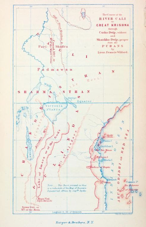
books. Most of them contain several books themselves and many are thousands of pages. Most of them contain a traditional Hindu Geography. F. Wilford, in Asiatic Researches made a map(given on top
with in red his constructed map and in blue what was known then from Africa) in the early 18-hundreds based on those geographies.
Speake when in Zanzibar preparing for his second trip to Lake Victoria was given the map. He mentioned it in his journal full of praise for the Hindus who had found out about the sources of the Nile. In later editions of his journal the passage was left out. The importance of this map however is that Speake's first edition is published on the web, and that several Hindu-nationalist web pages also quote it.
Speake when in Zanzibar preparing for his second trip to Lake Victoria was given the map. He mentioned it in his journal full of praise for the Hindus who had found out about the sources of the Nile. In later editions of his journal the passage was left out. The importance of this map however is that Speake's first edition is published on the web, and that several Hindu-nationalist web pages also quote it.
The map traces the course of a river the Great Krishna through Cusha dvipa from a great lake in Chandristhan, Country of the Moon. The district bordering lake Victoria to the east is called Amara. (a correct name, today called Massai Mara). I went through the ten thousands of pages of the Purana's and could nowhere find anything coming close to a geography of East Africa. I also went through
three books who comment on the geographies of the Purana's and also found nothing. I came to the conclusion that we have here a map on which
were added the names found in the Purana's that fitted best and that they were fitted there where
they fit best. As an example I give part of the geography of the Varaha Purana there where it describes the country or island or continent of
Cusha dvipa.
Now listen to Kusadvipa, the third (continent). Kusadvipa is surrounded by a milky ocean, and is double in extent of
the Sakadvipa. There are seven major mountains here also, each with two names such as Kumuda, also called
Vidruma. The high Hemaparvata is also Drona, Puspavan is also Kanka, Kusesaya is also Agniman, and the sixth
Mahisa is also Hari. Agni remains there.
The seventh is Kakudhra; it is the same as Mandara. These are the mountains in Kusadvipa. The divisions in it have
The seventh is Kakudhra; it is the same as Mandara. These are the mountains in Kusadvipa. The divisions in it have
also two names each. Kumuda is Sveta, it is named first. The high Lolita is also Venumandala. Valahaka is Jimuta and
is the same as Rathakara. Drona is Hari and is the same as Baladhana.
The rivers there have also two names. Pratoya is also called Pravesa. The second is Siva, also called Yasoda. The
The rivers there have also two names. Pratoya is also called Pravesa. The second is Siva, also called Yasoda. The
third is Citra, also known as Krsna. The fourth is Hradini, also called Candra. The fifth is Vidyullata, also called
Sukla.
The sixth is Varna, it is the same as Dhrti. These are the main rivers. The others are minors ones. This is the
arrangement in Kusadvipa.
Note: Sircar D. C. has in several of his books put forward the idea that Kusadvipa is related to Kush; the country on
Note: Sircar D. C. has in several of his books put forward the idea that Kusadvipa is related to Kush; the country on
the Nile between Egypt and Ethiopia. It got to be known in India as it was the border of the neighboring Persian empire
where several inscriptions mention it.
According to numerous authors (but not all) East Africa should be Sancha dwipa. The following extract is taken from:
According to numerous authors (but not all) East Africa should be Sancha dwipa. The following extract is taken from:
Asiatick Researches: Or, Transactions of the Society Instituted in Bengal, for Inquiring Into the...By India Asiatic Society
Calcutta P307-308 (1808). The dwipa of Sancha is supposed, by the Pauranics, to join the island of Sumatra, or of the
Moon. This mistaken notion has been adopted by Ptolemy, and after him by Oriental writers. In the beginning of
the
Brahmanda-purana, Lanca or the peninsula of Malaya, and Sumatra join the island of Sancha, or Zengh…..
The tract of islands called Raneh by Arabian writers, and including Madagascar and the surrounding islands, is
The tract of islands called Raneh by Arabian writers, and including Madagascar and the surrounding islands, is
obviously the dwipa of Harina, mentioned in the Bhagavata, along with Sancha, in the South-West quarter of the old
continent. This island being also called in Arabic, the island of the moon, has occasioned some
confusion.