Back to Table of Contents 7 To next page
The translation of the East African part of the Maokun map (1)
Works used: Mills, J. V. G., trans., ed. Ma Huan, Ying-yai Sheng-lan: The Overall Survey of the Ocean’s Shores (1433). Hakluyt Society Extra Series 42. Cambridge, England: Cambridge University Press. 1970
Zheng He and the African Horizon: An Investigative Study into the Chinese Geography of Early Fifteenth-Century Eastern Africa. By Clifford J Pereira.
"Zheng He's Navigation Chart" is not the "Complete Navigation Chart of Zheng He's Fleet" by Zhang Zhiqiang.

Note: the measurements in fingers and quarters are all measured from the North star of the Little Bear called Pei Chen.
Note: Pereira is the author who stated that Malindi, placed as the most southern town in Africa on the Maokun map is not placed far too much south as the other authors write; and that those other places need to be identified north of Malindi. This total mix up of place names in north and south East Africa does not do justice to the Chinese intellectuals of the Ming fleet.
Folio 20R
1) 哈甫泥 : Ha fu ni The drawing of Ras Hafuni (11°50’N) shows the enormous promontory stretching into the sea. (A similar drawing Maokun used to show the promontory of Ras Ngomeini under.) Nobody doubts this identification of the place-name.
2) Pei ch’en (Bei chen, Polaris), Four fingers, one quarter (6°49’N).
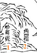

3) 木兒立哈必兒 : Mu er li ha bi er. Mills (1970) : Mu-er-li Ha-pi-erh (Muerli Habier) Morro-Khebir/Ras Mabber (9°28’N) Pereira agrees with it. The landmark is also known now as Bandarbeyla. Zhang Zhiqiang has Hobia (Hobyo).


4) 黑兒 : Hei er The drawing shows three mountains with the name in the biggest one. There is only one place on the coast where such promontory exists. It is 6 km from the first to the third promontory. (In straight line). Mills: Hei-erh (Heir) Ras el Cheil (Cape), (7°44’N). Pereira agrees with it. Zhang Zhiqiang has undefined. As Ras el Cheil is really the old name of the southern promontory while in the drawing the name is written in the most northern one; I give it the name of the northern promontory: Ras Illig.
Sulaiman al-Mahri (1515) has: … at 1.5 isba (fingers) of Pole Star is Hatha and al
Damiun ….. According to Horton (2018) al-Dhanane must be al Damiun.
5) Pei ch’en (Bei chen, Polaris), Three fingers, one quarter (5°12’N).

Note: Al Idrissi (1150) has a place in the gulf just before Hei-er called Markah.

6) 剌思那呵 : La si na he; Zhang
Zhiqiang has undefined. Mills: La-ssu
Na-ha (Lasi Naha) ‘Ras Naha’, Ras Assuad (4°33’N). Pereira agrees with it.The reason given is that Idrissi
(1150) gives a place ‘Al-Nadja’ somewhere in this wide area. The only thing special of Ras Assuad is that it is the place where the bearing changes from SSW to SW and this for a stretch of
300 km.
My choice for Ras Naha is: Bur Gol hill of
Ras Cabad which is the only other big promontory to the south (of Hei er) and only landmark in a big area, it sticks 2 km out in the sea and has a hill Bur Gol sticking up on the south of it.
Since the nineteenth century provided with a beacon for the ships. It is at 6°20’N. Except of it being the only landmark on the route it also agrees with the drawing given by Maokun: First the
beachhead followed by the bigger hill in which the name is written. And Al Nadja of Idrissi might be the Gulf with the water-points preceding it.


mapcarta found it necessary to add Bur Gol to its map of Ras Cabad.

7) 抹兒幹别 : Mo er gan bie. According to Mills: Mo-erh Kan-pieh which he makes into a repetition of Ras Mabber (9°28’N). Pereira has Mareeq (3°46’N). Zhang Zhiqiang has undefined. According to me this is the first town in a drawing of three towns close together (neighbors) And in the middle is Mogadishu and south of it Merka. The northern one must be Warsheikh (at 2°20’N) as no other town is found in the area. The three towns were also united in the Ajuran empire but retained their own government. The town of Warsheikh later came under the administration of the Hiraab Imamate in the late 17th century. Its historical center is about 5ha and might be as old as 11th century. Medieval coins from Mogadishu were found in the place. But no real archaeological work has been done there.
8) Pei ch’en (Bei chen, Polaris), Two fingers, one quarter (3°36’N)
9) 木骨都束 : Mu gu dou shu ; The second town in the drawing of three. The present capital of Somalia and Mills and Pereira and Zhang Zhiqiang have Muqdishu (2°02N).
10) see next page.

