Ibn Majid (1470) is the only author to mention this place.
Taken from: Taken from: Madagascar, Comores et Mascareignes à travers la Hawiya d'Ibn Magid (866 H. /1462). Par François VIRE et Jean-Claude HEBERT.
This Arabicized toponym in Sa'da (Sa'ada “happiness” in Sulayman) is transcribed Sada, Saada or Cada/dadi by Europeans; it would be, according to Grandidier (C.O.A.CM, II, 260 note 1) “a word which in the language of the Antalaotra or Arabs of the north-west of Madagascar and it means “fort”. These Arabs had sadas or forts at various points on the northwest coast, notably in the place of the modern Anorontsanga and at the bottom of the bay of Ampasindava; it is therefore not surprising that the ancient authors gave this name to different bays and islands”. Prospecting by P. Vérin confirms these statements in all respects (see op. cit. 11, 582 s. for Anorontsanga, and II, 617 s. for the site of Mahilaka at the bottom of the bay of Ampasindava). In addition to these two Sadas attested for a long time (see the maps of Gastaldo, 1567, and Porcacchi, 1572), there is still a Sada on the north-west coast New Massage on the islet of Antsoheribory, in the bay of Boeny, just as Lobo de Souza (1557) named Sada the island Nosy Manja of the Old Massage. The bay of Baly also has a Sada located at the tip of the promontory called Cap Est or Cap Sada.


Moreover, on the maps of Wilde (1650) and Fitzhugh (1683), Nosy Be itself is called Asada (see reproduction in Vérin, op. cit. I, 23). This plurality of Sada is typical of the north-west coast and it is of one of them, placed more than nine fingers above the Big Dipper that Ibn Majid speaks in this verse. However, misled by a faulty interpretation by Grosset-Grange who neglected the meaning of the expression min sawb Sa'da, Vérin, following him, admitted the existence of a Sada on the east coast by saying: “Cape Masoala bore the name of Saada...” "It is in our opinion an error of interpretation because by saying min sawb 'Sa'da 'from the position of S." that is to say "from the latitude of S.", lbn Majid understands that once the cape of Amber (= cap du sel) has been crossed, whoever wants to go to the Mascareignes must go down again along the coast to a latitude corresponding to that of Sada which is on the other side, and, from there, take the course indicated. This latitude being "more than nine fingers", this Sada of Ibn Majid would have been south of Langany Vieux Masselage which is increased to ten fingers. But, later, in his poem al-Sufaliyya, Ibn Majid corrected its height of Sada, carrying it to a little more than ten fingers, which puts it at the site of Mahilaka, at the bottom of the bay of Ampasindava, at some 12° above the fourteenth parallel. L. Millot (1912) and Ch. Poirier (1947), P. Vérin, more methodical, actually recognized, in the site of Mahilaka, the important vestiges of an old fortress, a mosque, houses, the whole having provided numerous fragments of ceramics whose study would date this Muslim establishment to the 12th century. Some more recent pieces show that this place was still functioning in the 15th and 16th centuries. On the east coast, this latitude drops to about fifty kilometers south of Vohemar and that of Sada/Anorontsanga at a ten kilometers further south. In any case, the course aimed, from these points, at Reunion Island given by Ibn Majid, i.e. SSE (= 157° 30), is much too far to the west and would take the ship almost halfway between Manakara and the island; the right course would have been between the rhumb of Scorpion (SE = 135°) and that of Deux Anes (SE1/4S = 146° 15°).
Taken from: L’évolution des systèmes d’installation dans la baie d’Ampasindava et à Nosy-B; Henry T.Wright et Radimilahy Chantal traduit par Claude Allibert. 2005

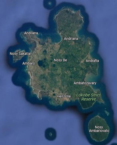
Not all sites are mentioned in the text. Sites on Nosy Be of the 11th-14th century.
- Madirokely (facing south towards the mouth of Ampasindava Bay). The whole covering about 3.1 ha. Many ceramics from the surface. A red-hot vessel with graphite designs and shards of chlorite schist vessels may be imports from other parts of Madagascar. Shards of sgraffiato bowls with apple-green glaze and crude floral designs, imported from the Near East, indicate occupation dating back to the 13th century.
- Sangaravo-Dzamanjary is facing west, old shards cover 0.4 ha.
- Ambanivato Atsimo is facing west covering 2.1 ha. Local ceramic include rims of bowls. Among the imported objects are a rim of a vessel turned red with black and white painted designs and pot shards in chlorite schist and a bowl shard in yellow-glazed sgraffiato and brown.
- Ambaro Atsimo western coast of Nosy Be 0.45 ha. It has strong and coarse sherds, including jar rims, chlorite schist sherds, green glazed stoneware sherd from the Far East, and sgraffiato bowl sherds from the Near East.
- Ambakirano Atsimo faces north and covers 0.5 ha. The only imported shard is a handle without particular
characters of unknown origin.
- Ambakirano Center covering 1.1 ha. It has local sherds but no imports.
- Ambakirano Avaratra facing northwest of 0.5 ha. Sherds of this time-span. Imports of brown and yellow glazed sgraffiato bowls and chlorite schist pots.
- Antanambe/Sakatia faces south about 0.30 ha. Has strong potsherds including the foot of a tripod or tetrapod, the clay copy of a pot foot in chlorite schist. It was probably a single row of houses facing the beach.
- Ampasindava/Sakatia facing north and 0.10 ha. Among the rare sherds found are a bowl rim, a jar rim with zig-zag incisions and, a possible rim of imported bowl reddened with painted graphite and white designs.
- Andilana Atsinanana (only two houses) on the northwest about 0.1
ha.
- Amparihibe Atsinanana (northwest) covering 2.0 ha.: poor in thick and coarse sherds, including two undecorated jar rims and a circular base.
- Andavakabe northwestern part about 0.5 ha. It was just a row of houses.
There are also several badly damaged sites. If these villages were occupied at the same time, the distance from
one village to another was regular, ranging from 2.3 km to 3.6 km. By its large size and its central position, it is possible that Ambanivato was the main site in the west of Nosy Be for a time
between the 11th and 14th centuries.
The character of these sites in Nosy-Be and along the coasts of the bay of Ampasimbava has implications: Very small hamlets are found in exposed places. So, at least for part of these four centuries, attacks were not feared. On Nosy-Be only hamlets were found but on the southeast coast of Ampasindava Bay, we have a center with defenses, with specialized jobs and businesses, international organizations and mosques, all surrounded by small settlements.
Surprisingly there is no clear mention of this part of Madagascar among 12th-14th century Islamic geographers.

Not all sites are mentioned in the text. Sites in Nosy-Be of the15-16 century.
The sites are similar to those of the previous period but they are few in number. The occupation continues on some sites of Nosy-Be:
- Madirokely south coast of Nosy-Be, has a few sherds all indicating that the occupation lasted until the Mamoko phase.
-Ambakirano Avaratra has a wave combed sherd, a reddish basin rim and a flared jar rim from the Mamoko phase.
- Amparihibe Avaratra on the north-eastern interior part of Nosy-Be. Among these shards was the thickened rim of a characteristic bowl. From a single house or camp.
In summary, a large number of known settlements survive. The large town with evidence of long-distance trade is
apparently still occupied, although on a reduced scale. A simple hamlet or camp indicates that the interior of Nosy-Be is still exploited. The discovery of fewer sites and fewer shards does not
always mean that there were fewer people - since the duration spanned two centuries represents only half of the former period - yet it is true that the sites seem smaller. It is therefore
possible that the population was lower.
The end of this period corresponds to the first evocations of the Itongomaro kingdom in the Ampasindava region by Portuguese visitors. This kingdom is indicated on the Turin globe in 1523.
Diégo de Cuoto reporting the voyage of Baltazar Lobo de Suza in 1557 writes that there is a “…king named Tungumaro, the most powerful of all those on the island, this king continually makes war on his neighbors and sells his prisoners to the Moors of Sada Island". This island may have been Nosy-Be, sometimes called Assada.
An Englishmen called Hunt who tried to create a colony in Nosy-Be (then called Assada) repeats the account of a visit made by English merchants before 1645 probably to the same city. “In the bay of Assada, an English ship which stopped there on its way to India found a small town called Antasia (Antafia?), where the Arabs come every year to load several dhows of rice which they buy with arquebuses, knives and Indian fabrics.
Taken from : Islamic Archaeology in the Comoros: The Swahili and the Rock Crystal Trade with the Abbasid and Fatimid Caliphates by Stéphane Pradines
The rock crystal is often portrayed as coming from Vohemar or Nosy Be, but these were merely the loading ports and not the location of the mines (Lacroix 1923, 109–110).
Taken from : The Culture History of Madagascar; Robert E. Dewar and Henry T. Wright
Sometime around the end of the fourteenth century Mahilaka and its surrounding hamlets and the villages on Nosy Be were largely deserted. Whether people abandoned these areas because the focus of international relations shifted elsewhere, for example, to Vohemar on the northeast coast, or because there were local problems, is unknown.
Scattered villages including Nosy Be and Irodo, are known from the northeast and northwest coasts but with little direct evidence for Islam.