Back to Table of Contents
(5)
To next page
The Barbari gulf forms a triangle….. on the western leg of the triangle are situated the countries of the Habacha infidels, part of the Zandj, and towards the east the land of the Habacha Muslims….. the side of the continent, a part of the lands of the Zandj and the Habacha, here is situated Maqdichou opposite Zafar (2) or al-chihr (3)….
Then the islands of the Zandj, which are very numerous, like the island of Qanbalu (4) situated at 1 or 2 days distance of the Zandj coast; its people are Muslims who settled there in the beginning of the Abbasid period. The water of this island flows into the sea of Oman; this country is at about 500 farsakhs (5) distance. It is here that a branch of the Nile reaches the sea (12). The navigators on the sea of Oman say that during the floods of the Nile the effect is felled in Oman. The people of Mogadishu take profit of this branch of the Nile to water their crops and because of that their sugarcane and other crops are better there then anywhere else in the Soudan. To this reason the traders say is due their affluence and the floods or shortage of the Nile is a very sensible subject to them. There are however people that deny that a branch of the Nile goes down towards Oman but they have no reason to stand on….
The Nile has its origin in the mountains of the moon. First its 11 rivers that join in a swampy lake. Then they go through the sand and mountains of the region, and then the land of Nakta, black people like the Zandj and in the land where the gold grows. There it splits in two of which one branch goes to the sea at the island of Qanbalou as we already said (12). This branch goes through most of the land of the Zandj long and wide, from that branch to the land of Soufala is about 700 farsakhs (5)….
The first clime starts…. Through the islands of Diwa (6) and the northern part of the islands of Zandj and the biggest part of the land of those people. After the Zandj it reaches the Soudan from where the black eunuchs come then north of the mountains of the moon….The inhabitants …. Have often defects in their natural qualities what is proven with the ugliness like the Zandj and the Habacha in the first clime.
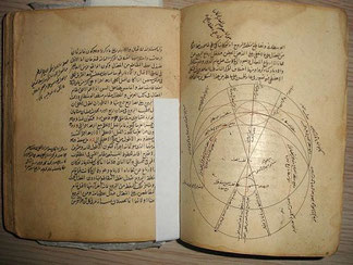
Qutb al-Din al-Shirazi (1281) Nihayat al-idrak fi dirayat al-aflak
(The complete understanding of the spheres) from Persia
------------------------------------------------------
Taken from: The Historical and Cosmographical Context of Hayʾat al-arḍ with a Focus on Quṭb al-Dīn Shīrāzī’s Nihāyat al-Idrāk by Fateme Savadi.
P272
…. Later, he (Ptolemy) became aware of the inhabited areas beyond the equator to the south up to the [latitude of] 16 degrees and a quarter and a sixth [of a degree]. Thus, in his book entitled Geographia he said that the initial latitude of the inhabited world from the south is where the altitude of the southern pole is 16 degrees and a quarter and a sixth [of a degree], these being populated regions at the farthest reaches of Zanj region, Abyssinia [al-Habasha], and some other [areas] that have been reported to be southerly.
P273 (About the seas.)
…. The sea surrounds, on most sides, the part of the earth (that is, the inhabited), and is known in the west, north, and most of the south, and especially the eastern site. With regard to the south-western sea, it is reported that in the direction of the sources of the Egyptian Nile travelers travel to places whose southern latitude is somewhat greater than 10 °; They then, with their own eyes, perceive the snow-white mountains, which are named after the moon (note 1), and from which the springs of the Nile spring. These mountains lie south of the travelers in the distance; but the latter do not reach the sea.
(note 1)
In the margin, we find the following remark: This mountain is only connected to the moon, because in the early months of the moon the white color of the moon reaches it ; The white color is increased in the second night, the rays are still stronger in the third and fourth, the fifth is red, and the light is very intense, the sixth one is seen on it, In the seventh it is green and bright, the final result is that it shows colors every night until the middle of the month in the night of the full moon it is dyed like the tail of the peacock, and its light and its rays grow - after the experience of eye-witnesses. There lies Nubia and al Habascha, as mentioned in the geography.
P273-4
……… You should know that in the area that has been uncovered to allow for habitation, there are also numerous bodies of water some of which are connected to the Encompassing [Ocean] and some are unconnected to it; among those connected are the Sea of Oman [ʿUman], which is called the Sea of Persia, India and China [Bahr al-Fars wa-al-Hind wa-al-Sin]; it is the largest of them all, beginning from the farthest [part] of the regions of China and India to the farthest [part] of the regions of Abyssinia and Barbary [Barbar], not where western Sudan [region] is, according to what is commonly thought. Indeed, it is not correct, because this Barbary is not the Barbary that is in western Ifriqiyya region. If that [Barbary] was meant, then the length of [Sea of Oman] would be greater than what is agreed upon, which is 2660 farsakhs (5). Its width is 900 farsakhs, of which 360 or 330 farsakhs (5), according to two different opinions, is north of the equator and the rest is south of it. The equator passes through most of this sea. This is the southern sea, which is connected to the eastern side of the Encompassing [Ocean], from which extends four gulfs into the middle of the inhabited region. The first is the Gulf of Barbary [al-Khalij al-Barbari], inasmuch as it borders Barbary [region], and this [gulf] is the nearest of them to the Maghrib. Its length on the northern side is 160 farsakhs, and its width at its base, and, as has been said, at its end is 35 farsakhs (5).
P285 (about the middle line of the first clime)
…….. through the Hijaz region and most towns of Yemen such as al-Mid (13), Madinat al-Tib (14)/al-Tayb, Muʿalla, Hadramawt (15), Sanʿa, Mara (16), Zabid (17), Qalhat (18), Zafar (19), Shihr (20), and Aden. It then passes across the Red Gulf and the towns of Abyssinia, Sudan and al-Nuba regions, such as Jarma, the capital of Abyssinia, Dunqula (21), madinat al-Nuba, Ghana the gold mine of western Sudan region, then the Barbary region until it reaches the western Ocean. (In some manuscripts is added) Some of its regions are western Sudan and some provinces of Barbary and Yemen, and the regions of Abyssinia and al-Zanj, and Indian islands to the borders of China.
P288
……… The equator begins east of China and goes over an island called by the Indian Gamkut, then through the southern parts of al Sin, then over Dizkank (note 2)(7), across the shores of the southern sea and the rivers where the ships from the sea have access, then over the places of India, Sarandib (22), the places of al-Si'mi, and then in the sea over the island of Kark (23), governed by a governor on behalf of the King of Yemen which tithes from tithing ships. He then cuts the sea to Arabia and Yemen; he encounters what is south of the places of Yemen, such as San'a (8), Zafar (2), Hadramaut (9), and Al Aden; Then he crosses the bosom of the green sea, goes through al Habasha, the Negroes, on it lies the city of Nubia and Isqutara (Suqutraj - Socotra), and goes to al Magrib over the places the barbarian until he reaches the surrounding sea reached.
(note 2)
In the margin, we find the following remark: About the island of Zawa which is called the gold island, then by the south of the island of Sirandib, between the islands of Kalah (10) and Sribua (11), through the Diwa (6) islands, on the north of the islands of the Zanj, and to the north of most of their country. After having crossed the border of their country through the desserts and steppe of the Negroes, to the north of the mountains of Komr, to the south of the Negroes of the Magrib till it reaches the all encircling sea called Muhit.
P295
…….. The truth of the matter is that if one means by temperate a uniformity in the conditions, then there is no doubt that it is most so at the equator, as opposed to the fourth clime. But if one means by it a balancing of the two [extreme] weather conditions, then there is no doubt that it is more so in the fourth clime, as opposed to the equator; this is indicated by the extreme blackness in color of its inhabitants among the peoples of Zanj and Abyssinia, the extreme frizziness of their hair, and other things that are brought about by the heat of the air. The opposite of this among the people of the fourth clime indicates that the state of its air is more temperate.
(1) Siraf: was the harbour of Shiraz province of Persia; and the place of big trade with East Africa.
(2) Zafar: or Dhafar is an ancient Himyarite site situated in Yemen, some 130 km south-south-east of today's capital, Sana'a.
(3) al-chihr: or Shihr; coastal town in Hadhramaut in eastern Yemen.
(4) Qanbalu: Qanbuluh: The island of Qanbalu from where the Zanj slaves were imported till the great Zanj revolt in Basra. (Zanzibar or Pemba).
(5) Farsakhs: Parasang: 1 parasangs or farsakhs = 2.8 nautical miles/ about 5km.
(6) islands of Diwa: Diwa means island in Sanskrit, here the Maldives.
(7) Dizkank; is part of China.
(8) San'a: now capital of Yemen.
(9) Hadramaut: eastern part of Yemen.
(10) Kalah: very important harbour in Malaysia in those days.
(11) Sribua: an island Cherboua (Sribuza or Sharbua) is found with Idrisi (1150); Yakut (1220) has Sribuza; Ibn Said (1250) Serira; Al Umari (1349) Cherboh; Qoutb al-Din al-Chirazi (1311) Sribua.
(12) Nil of Maqdishu: Nile of Mogadishu (Here called Nile of Qanbalu): This is the Shabelle River begins in the highlands of Ethiopia, and then flows southeast into Somalia towards Mogadishu. Near Mogadishu, it turns sharply southwest, where it follows the coast. Below Mogadishu, the river becomes seasonal.
Al Zuhri : (1137) Makes the people divert themselves the Nile into a branch to the sea of Yemen; In Dimashqi (1325) it is called the river of Damadim; and he is the only one who kind of understands the river-system in South-Somalia. Salamanca translator (1420): calls it yellow Nile. Ibn Khaldun (1406) says it has nothing to do with the Nile. Nile of Mogadishu appears in Ibn Said al Maghribi (1250); Cowar el-aqalim (1347); Abulfida (1331); al Maqrizi (1441)he calls it River of the Damadim ; Hafiz I Abru (1420); Qoutb al-Din al-Chirazi (1311); Al Qalqashandi (d1418); Qadi Ibn Sasri Al-Shafi’I (1300) Cowar el-aqalim (1347).
(13) Al Mid’ah in Ash Shamayatayn is a town located in Yemen about 241 km south of the capital Sanaa.
(14) literally city of gold.
(15) Hadhramaut is a region in South Arabia, comprising eastern Yemen, parts of western Oman and southern Saudi Arabia.
(16) Al Mahrah, or simply Mahra, is a governorate of Yemen, bordering Oman.
(17) Zabid is one of the coastal towns in Tehama area west of Yemen
(18) Qalhat is located on the coast of Oman about 25 km from Sur and 60 km from the easternmost corner of Arabia.
(19)Zafar, also called Dhafar, is an ancient Himyarite site situated in Yemen, some 130 km south-south-east of today's capital, Sana'a.
(20) Shihr: coastal town in Hadhramaut in eastern Yemen.
(21) Dongola: Old Dongola is a deserted town in what is now Northern State, Sudan.
(22) Ceylon
(23) Abu Nasr Mutahhar al-Maqdisi (966) writes a lot on the Kark: The Kark: This is a nation that descends from Sudan son of Kanaan, they live close to the people of Sind and Zandjs, who are their enemies. The Kark are strong people of high statue, long hair, a beautiful face, skilled in the art of war..... The Kark have as neighbors on the side of the Zandjs more nations and tribes then can be written down. The Zandj and the Kark touch at the people of Sind and Hind and to the Band.....
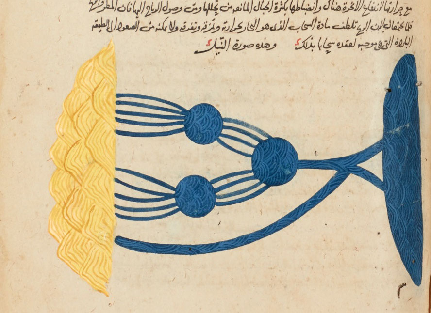
Qutb al-Din al-Shirazi Kulliyat al-Qanun (Commentary on the Qanon(d.1311)
-----------------------------------------------------------------------------------
Taken from; http://www.sothebys.com/en/auctions/ecatalogue/2018/arts-of-the-islamic-world-l18220/lot.12.html
Mahmud ibn Massud Qutb al-Din al-Shirazi; in his Kulliyat al-Qanun, a commentary on the first volume
of Al-Qanun of Ibn Sina, book II, Egypt, Mamluk, copy dated 739 AH/1338-39 AD.
I did not find the text of the book only the beautiful map of the sources of the Nile.
Qoutb al-Din al-Chirazi; (1311) Ikhtiarat Mozafari: (Mozaffari's Choise)
------------------------------------------------------------------------------------------------------------
Taken from: noorlib.ir اختیارات مظفری by قطب الدین شیرازی، محمود بن مسعود
…… and the Berber dwellings and the areas of Sus Adna and Sus Aqsa; (Sus al Adna: Atlantic Moroco with Fez as capital + Sus al-Aqsa (Sus the Remote) was a town in Morocco; It was located near Tangier) the areas of the upper and lower places; and the land of black people will be in the west south of the equator. Then turn left to the other side of the Qamar Mountains, where the sources of the Egyptian Nile River come from and then there is the whole sea of Sofala Al-Zanj. And the most remote country those are the Zanj.
……….. And the destination of the ships of Omanis and Sirafians in the bay of Zanj, is the country of Waq Waq, at the bottom of the Zanj country. But the ships do not venture (to the bottom). They do not come and they do not go because of safely. And for this reason, they don't know what is joined to the eastern areas, which cover most of this quarter, i.e. the south western quarter.
And the whole quarter South East, as said by Master Abu-Rihan (=Abu Raiḥan Muḥammad Ibn Aḥmad Al-Biruni). He is also a bit of a poet. As clearly indicated by the words of the Lord (=Author of the Book) Masalik al Mamalik (Of Roads and Kingdoms.) It implies what they said that the land mass is over half of the length of the equator which extends along all Islamic countries …………..
………………. And the investigation of this enabled them to find out from the travelers and traders from the al-Zanj area, whose length is sixty-six degrees from the west and one degree width from the south, is on the extreme shore of the sea that comes from the east, …………
……….. And the goal of the Omani ships and the Sirafians is Sofala of Bahr Zanj, and also Bilad Waq Waq which is close to Sofala of Bilad Zanj; but they do not bring the ships upto there, and if they do; they do not leave safely. And that's why they don't know the current joining (of the lands over there). ……..
……….. And this category is assumed to be close to the equator. Three bays come out (of the ocean): All of the Barbary Gulf and it is triangular in shape. And the length in the north is one hundred and sixty farsang, and its western side falls on the same bend where the equator is it is up to one hundred and sixty miles. And on the west side of this side was Abyssinia. And some of the province of Zanj and its eastern side will be turned at an angle and then it becomes parallel (to the equator). The base of the triangle was thirty-five (farsangs) from the parallel line. And this is what is meant by what is mentioned in the famous books that the width of the Barbary Gulf is originally thirty-five farsangs.. ………..