Da Ming Hun Yi Tu (1389)
(Amalgamated map of the great Ming empire)
----------------------------------------------------
Taken from: news.bbc.co.uk and ruf.rice.edu and uni.erfurt.de and taint.org and exboard.com

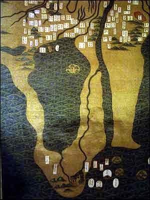
This map is said to be the oldest map of the African continent with the continent facing south, and showing South Africa dating back to 1389.
The Chinese map covering more then 17 square
meters was produced in silk. It is thought to be a copy of a map sculpted into rock 20 or 30 years earlier. Many believe the mountains in the south are the Drakenbergen in South
Africa.
Drawn on a horizontal scale of 1:820,000 and a vertical scale of 1:1,060,000, it covers an area extending all the way from Japan to the Atlantic Ocean (including
both Europe and Africa), and from Mongolia to Java. Although the section on China seems to be derived primarily from Zhu Siben's Yutu, the renderings of Africa, Europe and Southeast Asia appear
to have been based at least in part on Li Zemin's Shengjiao guangbei tu (Map of the Vast Reach of [China's Moral] Teaching; c. 1330), no longer extant.
The map also shows a great lake, covering almost half the continents land mass. Researchers suggest it may have been drawn on the basis of an Arab legend that stated "further south from the Sahara Desert is a great lake, far greater than the Caspian
Sea".
The map of Zhu Siben originated by putting together Arabic and Chinese
sources.

The Arabic Source
1 桑骨人 or 桑骨八 Sang gu ren (Zangi people) or San gu ba (Zanzibar) (wrongly put on the west coast).
2 这中鲁哈麻 Zhe zhong lu ha ma : Takahashi 1963 restored it as Arabic jabal al-qamar, meaning Mountains of the Moon.
3 法那伊斯哇 Fa-na-yi-si-wa (Wang et al. 1994 p54) which in Chu Ssu pen is 哈纳伊斯哇 Ha na yi si wa; Hatt al Istiua; equator.
4 娣八奴 Di ba nu; Arabic diba from Sanskrit dvipa, meaning island. In Arabic manuscripts this is Maldives Islands archipelago and ‘nu’ Chinese for slaves. Or: Tabarna Arabic for Taprobane (Ceylon)of Ptolemy. (Kenzheakhmet p113)
5 库六 Ku liu ?? (Kilwa).
6 喝卒 He zu ?? (Pronounced: gou-tzoe) I think: Djeziret-el-Qeroud (pronounced el goe-roo) island overtaken by monkeys. For this see my web-page for Ibn Said al Maghribi (1250) Kitab Djoughrafiya.
7 失尔剌秃里那 Shi er la tu li na ?? with Chu ssu pen (1320) : 失阿剌秃里赤 Si a la tu li shi (Shih-a-la t'u-li-ch'ih) The Chinese web-book of the: Ancient Seven Seas Gazetteer (http://www.world10k.com/blog/?p=1335) on page 1335 translates 秃里赤Tu li shi as: ‘place of those made naked black and red’ and gives a list of books in which it is used. I think this must be translated here just as Sofala, a place of those made naked black and red.
8 冒西哈比那 Mao xi ha bi na ?? appears also at Chu ssu pen.
According to Nurlan Kenzheakhmet: 昌西哈必剌 Chang xi ha bi la = Zanj-I-Qanbala (Zanj of Qanbalu).
9 顆細打賓 Ke xi da bin ?? I think: Djezir Arin = dome of the earth. For this see my web-page for Ibn Said al Maghribi (1250) Kitab Djoughrafiya.
10 with Chu ssu pen and Ch'uan Chin and Li Hui: 哇阿哇 Wa a wa : according to my opinion this is to be Waq Waq.
-All the placenames that are transliterations are found in the work of Ibn Said al Maghribi (1250) Kitab Djoughrafiya. And Ibn Said makes them also all into islands off the east coast of Africa, except for Sofala which he puts on the main land.
-The names that give other information are in accordance with the information given by Muslim geographers. These are 4: Ti ba nu (Diba-nu) Island slaves. 7 Si a la tu li shi; Sofala, a place of those made naked black and red.
The Chinese Source.

Map of the islands on the very bottom of the map on the edge between Africa and Asia.
These islands exist also on several copies of the Kangnido’s. And they have as many inscriptions.
Of the three big islands on this map the lowest is East Africa, above it Arabia island, and above it South India island according to the Chinese sources. The explanation is that the Chinese sailors knew that if you cross the ocean starting from the Asian continent you come to South India crossing again you arrive in South Arabia and crossing again in East Africa.
I do not know the inscriptions here but those on the Kangnido maps give names of places for respectively East Africa, South Arabia and South India.